Recomienda este artículo a tus amigos:
Hadrian's Wall Path Map Booklet: 1:25,000 OS Route Mapping Mark Richards
¿Tienes un perfil? Iniciar sesión
Nuestros clientes opinan:


Añadir a tu lista de deseos de iMusic
También disponible como:
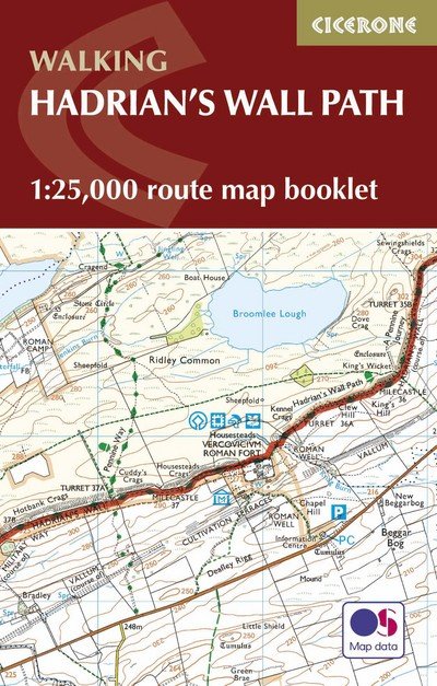
Hadrian's Wall Path Map Booklet: 1:25,000 OS Route Mapping
Mark Richards
Map of the 84 mile (135km) Hadrian's Wall Path National Trail, from Bowness-on-Solway to Wallsend, Newcastle. This booklet is included with the Cicerone guidebook to the trail, and shows the full route on OS 1:25,000 maps. The trail typically takes a week to walk, and is suitable for walkers at all levels of experience.
56 pages, 50 pages of OS 1:25,000 mapping.
| Medios de comunicación | Libros Paperback Book (Libro con tapa blanda y lomo encolado) |
| Publicado | 7 de diciembre de 2021 |
| ISBN13 | 9781852848934 |
| Editores | Cicerone Press |
| Páginas | 56 |
| Dimensiones | 170 × 114 × 6 mm · 62 g |
Mas por Mark Richards
Mostrar todo
![Cover for Mark Richards · Best Walks in the Lake District: 50 Great Mountain Days (Paperback Book) [2 Revised edition] (2026)](https://imusic.b-cdn.net/images/item/original/679/9781786312679.jpg?mark-richards-2026-best-walks-in-the-lake-district-50-great-mountain-days-paperback-book&class=scaled&v=1767058139)
![Cover for Mark Richards · Walking the Lake District Fells - Borrowdale: Scafell Pike, Catbells, Great Gable and the Derwentwater fells (Paperback Book) [2 Revised edition] (2025)](https://imusic.b-cdn.net/images/item/original/385/9781786310385.jpg?mark-richards-2025-walking-the-lake-district-fells-borrowdale-scafell-pike-catbells-great-gable-and-the-derwentwater-fells-paperback-book&class=scaled&v=1604581687)
![Cover for Mark Richards · Hadrian's Wall Path: National Trail: Described west-east and east-west (Paperback Book) [4 Revised edition] (2025)](https://imusic.b-cdn.net/images/item/original/504/9781786311504.jpg?mark-richards-2025-hadrian-s-wall-path-national-trail-described-west-east-and-east-west-paperback-book&class=scaled&v=1665011427)
![Cover for Mark Richards · Fundamentals of Software Architecture: A Modern Engineering Approach (Paperback Book) [2 Revised edition] (2025)](https://imusic.b-cdn.net/images/item/original/511/9781098175511.jpg?mark-richards-2025-fundamentals-of-software-architecture-a-modern-engineering-approach-paperback-book&class=scaled&v=1728347167)
![Cover for Mark Richards · A Practical Approach to Conveyancing - A Practical Approach (Paperback Book) [24 Revised edition] (2024)](https://imusic.b-cdn.net/images/item/original/365/9780198873365.jpg?mark-richards-2024-a-practical-approach-to-conveyancing-a-practical-approach-paperback-book&class=scaled&v=1711151165)
![Cover for Mark Richards · Walking the Lake District Fells - Keswick: Skiddaw, Blencathra and the North (Paperback Book) [2 Revised edition] (2024)](https://imusic.b-cdn.net/images/item/original/378/9781786310378.jpg?mark-richards-2024-walking-the-lake-district-fells-keswick-skiddaw-blencathra-and-the-north-paperback-book&class=scaled&v=1603165268)
![Cover for Mark Richards · Walking the Lake District Fells - Wasdale: The Scafells, Great Gable, Pillar (Paperback Book) [2 Revised edition] (2024)](https://imusic.b-cdn.net/images/item/original/316/9781786310316.jpg?mark-richards-2024-walking-the-lake-district-fells-wasdale-the-scafells-great-gable-pillar-paperback-book&class=scaled&v=1570392025)
![Cover for Mark Richards · Walking the Lake District Fells - Langdale: The Langdale Pikes and Bowfell (Paperback Book) [2 Revised edition] (2023)](https://imusic.b-cdn.net/images/item/original/323/9781786310323.jpg?mark-richards-2023-walking-the-lake-district-fells-langdale-the-langdale-pikes-and-bowfell-paperback-book&class=scaled&v=1570392026)


![Cover for Mark Richards · Walking the Lake District Fells - Coniston: The Old Man of Coniston, Swirl How, Wetherlam, Duddon valley and Eskdale (Paperback Book) [2 Revised edition] (2021)](https://imusic.b-cdn.net/images/item/original/392/9781786310392.jpg?mark-richards-2021-walking-the-lake-district-fells-coniston-the-old-man-of-coniston-swirl-how-wetherlam-duddon-valley-and-eskdale-paperback-book&class=scaled&v=1603707952)
![Cover for Mark Richards · Walking the Lake District Fells - Buttermere: High Stile, Grasmoor, Grisedale Pike and Haystacks (Paperback Book) [2 Revised edition] (2020)](https://imusic.b-cdn.net/images/item/original/361/9781786310361.jpg?mark-richards-2020-walking-the-lake-district-fells-buttermere-high-stile-grasmoor-grisedale-pike-and-haystacks-paperback-book&class=scaled&v=1603188511)
![Cover for Mark Richards · Walking the Lake District Fells - Patterdale: Helvellyn, Fairfield and the East (Paperback Book) [2 Revised edition] (2020)](https://imusic.b-cdn.net/images/item/original/347/9781786310347.jpg?mark-richards-2020-walking-the-lake-district-fells-patterdale-helvellyn-fairfield-and-the-east-paperback-book&class=scaled&v=1592856160)
![Cover for Mark Richards · Walking the Lake District Fells - Mardale and the Far East: High Street and Kentmere (Paperback Book) [2 Revised edition] (2020)](https://imusic.b-cdn.net/images/item/original/354/9781786310354.jpg?mark-richards-2020-walking-the-lake-district-fells-mardale-and-the-far-east-high-street-and-kentmere-paperback-book&class=scaled&v=1592150215)

![Cover for Mark Richards · Java Message Service 2e - O'Reilly Ser. (Paperback Book) [2 Revised edition] (2009)](https://imusic.b-cdn.net/images/item/original/049/9780596522049.jpg?mark-richards-2009-java-message-service-2e-o-reilly-ser-paperback-book&class=scaled&v=1542310642)


Mere med samme udgiver
![Cover for Mark Eddy · Hikes and scrambles in the Costa Blanca: 40 mountain walks and scrambles (Paperback Book) [2 Revised edition] (2027)](https://imusic-static.b-cdn.net/images/missing-tall.png)
![Cover for The Reverend Sandy Brown · Camino de Santiago: Camino Frances: St-Jean-Pied-de-Port to Santiago de Compostela (Paperback Book) [2 Revised edition] (2027)](https://imusic.b-cdn.net/images/item/original/126/9781786313126.jpg?the-reverend-sandy-brown-2027-camino-de-santiago-camino-frances-st-jean-pied-de-port-to-santiago-de-compostela-paperback-book&class=scaled&v=1771273754)
![Cover for Peter Edwards · Mountain Biking on the South Downs: 26 graded routes including the South Downs Way (Paperback Book) [2 Revised edition] (2026)](https://imusic.b-cdn.net/images/item/original/597/9781786311597.jpg?peter-edwards-2026-mountain-biking-on-the-south-downs-26-graded-routes-including-the-south-downs-way-paperback-book&class=scaled&v=1664474351)

![Cover for Kev Reynolds · Trekking Chamonix to Zermatt: The classic Walker's Haute Route (Paperback Book) [8 Revised edition] (2026)](https://imusic.b-cdn.net/images/item/original/119/9781786313119.jpg?kev-reynolds-2026-trekking-chamonix-to-zermatt-the-classic-walker-s-haute-route-paperback-book&class=scaled&v=1779111494)
![Cover for Paddy Dillon · Walking and Trekking in Iceland: 100 days of walking and multi-day treks including the Laugavegur Trail (Paperback Book) [3 Revised edition] (2026)](https://imusic.b-cdn.net/images/item/original/856/9781786311856.jpg?paddy-dillon-2026-walking-and-trekking-in-iceland-100-days-of-walking-and-multi-day-treks-including-the-laugavegur-trail-paperback-book&class=scaled&v=1779111498)

![Cover for Gillian Price · Hiking Portugal's Rota Vicentina: The Fishermen's Trail and a summary of the Historical Way (Paperback Book) [3 Revised edition] (2026)](https://imusic.b-cdn.net/images/item/original/416/9781786313416.jpg?gillian-price-2026-hiking-portugal-s-rota-vicentina-the-fishermen-s-trail-and-a-summary-of-the-historical-way-paperback-book&class=scaled&v=1779111499)
![Cover for Dave Whitson · The Camino Ingles and Camino del Mar: To Santiago de Compostela from Ferrol, A Coruna or Ribadeo (Paperback Book) [4 Revised edition] (2026)](https://imusic.b-cdn.net/images/item/original/249/9781786313249.jpg?dave-whitson-2026-the-camino-ingles-and-camino-del-mar-to-santiago-de-compostela-from-ferrol-a-coruna-or-ribadeo-paperback-book&class=scaled&v=1777210763)

![Cover for Terry Marsh · Walking the Coast to Coast Path: NATIONAL TRAIL - St Bees to Robin Hood's Bay (Paperback Book) [5 Revised edition] (2026)](https://imusic.b-cdn.net/images/item/original/068/9781786312068.jpg?terry-marsh-2026-walking-the-coast-to-coast-path-national-trail-st-bees-to-robin-hood-s-bay-paperback-book&class=scaled&v=1771148759)
![Cover for Terry Marsh · Walking the Coast to Coast Path Trail Map: Complete 1:25,000 OS trail map for the full National Trail (Paperback Book) [2 Revised edition] (2026)](https://imusic.b-cdn.net/images/item/original/075/9781786312075.jpg?terry-marsh-2026-walking-the-coast-to-coast-path-trail-map-complete-1-25-000-os-trail-map-for-the-full-national-trail-paperback-book&class=scaled&v=1769444607)
![Cover for Mike Dunn · Offa's Dyke Path: National Trail following the English-Welsh border (Paperback Book) [2 Revised edition] (2026)](https://imusic.b-cdn.net/images/item/original/792/9781786312792.jpg?mike-dunn-2026-offa-s-dyke-path-national-trail-following-the-english-welsh-border-paperback-book&class=scaled&v=1771273660)


![Cover for Offa's Dyke Path Trail Map: Complete 1:25,000 OS Maps for the National Trail route (Paperback Book) [2 Revised edition] (2026)](https://imusic.b-cdn.net/images/item/original/808/9781786312808.jpg?2026-offa-s-dyke-path-trail-map-complete-1-25-000-os-maps-for-the-national-trail-route-paperback-book&class=scaled&v=1772488833)


![Cover for Sue Viccars · The Two Moors Way: Devon's Coast to Coast: Wembury Bay to Lynmouth (Paperback Book) [3 Revised edition] (2026)](https://imusic.b-cdn.net/images/item/original/171/9781786313171.jpg?sue-viccars-2026-the-two-moors-way-devon-s-coast-to-coast-wembury-bay-to-lynmouth-paperback-book&class=scaled&v=1768857489)
![Cover for Sue Viccars · The Two Moors Way Trail Map: Complete 1:25,000 OS Maps for the Route (Paperback Book) [2 Revised edition] (2026)](https://imusic.b-cdn.net/images/item/original/188/9781786313188.jpg?sue-viccars-2026-the-two-moors-way-trail-map-complete-1-25-000-os-maps-for-the-route-paperback-book&class=scaled&v=1768857491)
![Cover for Steve Davison · The Ridgeway National Trail: Avebury to Ivinghoe Beacon described in both directions (Paperback Book) [3 Revised edition] (2026)](https://imusic.b-cdn.net/images/item/original/914/9781786312914.jpg?steve-davison-2026-the-ridgeway-national-trail-avebury-to-ivinghoe-beacon-described-in-both-directions-paperback-book&class=scaled&v=1766515248)
![Cover for Steve Davison · The Ridgeway Trail Map: Complete 1:25,000 OS Maps for the National Trail Route (Paperback Book) [2 Revised edition] (2026)](https://imusic.b-cdn.net/images/item/original/921/9781786312921.jpg?steve-davison-2026-the-ridgeway-trail-map-complete-1-25-000-os-maps-for-the-national-trail-route-paperback-book&class=scaled&v=1766465705)

![Cover for James Rushforth · Via Ferratas of the Italian Dolomites Volume 2: 77 routes in the southern Dolomites a?? Brenta, Lake Garda, Pale di San Martino (Paperback Book) [2 Revised edition] (2026)](https://imusic.b-cdn.net/images/item/original/477/9781852848477.jpg?james-rushforth-2026-via-ferratas-of-the-italian-dolomites-volume-2-77-routes-in-the-southern-dolomites-a-brenta-lake-garda-pale-di-san-martino-paperback-book&class=scaled&v=1760972301)
![Cover for Kev Reynolds · The Cotswold Way: NATIONAL TRAIL Two-way trail guide - Chipping Campden to Bath (Paperback Book) [5 Revised edition] (2026)](https://imusic.b-cdn.net/images/item/original/105/9781786312105.jpg?kev-reynolds-2026-the-cotswold-way-national-trail-two-way-trail-guide-chipping-campden-to-bath-paperback-book&class=scaled&v=1695055614)
![Cover for John Gillham · Walking The Cumbria Way (Book) [2 Revised edition] (2026)](https://imusic.b-cdn.net/images/item/original/337/9781786311337.jpg?john-gillham-2026-walking-the-cumbria-way-book&class=scaled&v=1645941107)
![Cover for Rudolf Abraham · The Mountains of Montenegro: A Walker's and Trekker's Guide (Paperback Book) [2 Revised edition] (2026)](https://imusic.b-cdn.net/images/item/original/319/9781852847319.jpg?rudolf-abraham-2026-the-mountains-of-montenegro-a-walker-s-and-trekker-s-guide-paperback-book&class=scaled&v=1647822315)
![Cover for Dave Whitson · The Camino del Norte and Camino Primitivo: To Santiago de Compostela and Finisterre from Irun or Oviedo (Paperback Book) [3 Revised edition] (2026)](https://imusic.b-cdn.net/images/item/original/149/9781786310149.jpg?dave-whitson-2026-the-camino-del-norte-and-camino-primitivo-to-santiago-de-compostela-and-finisterre-from-irun-or-oviedo-paperback-book&class=scaled&v=1553552518)
![Cover for Paddy Dillon · Walking in the Isles of Scilly: 11 walks and 4 boat trips exploring the best of the islands (Paperback Book) [5 Revised edition] (2026)](https://imusic.b-cdn.net/images/item/original/047/9781786311047.jpg?paddy-dillon-2026-walking-in-the-isles-of-scilly-11-walks-and-4-boat-trips-exploring-the-best-of-the-islands-paperback-book&class=scaled&v=1606971158)
![Cover for Guy Hunter-Watts · Trekking the GR7 in Andalucia: From Tarifa to Puebla de Don Fadrique (Paperback Book) [3 Revised edition] (2026)](https://imusic.b-cdn.net/images/item/original/955/9781852849955.jpg?guy-hunter-watts-2026-trekking-the-gr7-in-andalucia-from-tarifa-to-puebla-de-don-fadrique-paperback-book&class=scaled&v=1647822418)
Ver todo de Mark Richards ( Ej. Paperback Book , Hardcover Book , Pamphlet , CD y Book )