Recomienda este artículo a tus amigos:
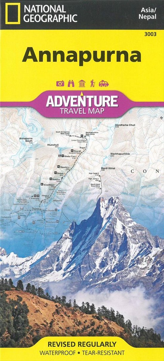
Annapurna, Nepal: Travel Maps International Adventure Map National Geographic


Annapurna, Nepal: Travel Maps International Adventure Map
National Geographic
National Geographic´s Annapurna, Nepal AdventureMap is designed to meet the unique needs of adventure travelers with its durability and accurate information. This folded map provides global travelers with the perfect combination of detail and perspective, highlighting hundreds of points of interest and the diverse and unique destinations within the country.
The map includes the locations of cities and towns with a user-friendly index, plus a clearly marked road network complete with distances and designations for major highways, main roads, and tracks and trails for those seeking to explore more remote regions. This detailed trekking map includes routes from Pokhara along the Marsyandi River, Thorung Pass, and the Kali Gandaki River in the Annapurna Conservation Area.
Every AdventureMap is printed on durable synthetic paper, making them waterproof, tear-resistant and tough - capable of withstanding the rigors of international travel.
1 pages, illustrations
| Medios de comunicación | Libros Map (Cartas terrestres o náuticas) |
| Publicado | 2 de agosto de 2012 |
| ISBN13 | 9781566955218 |
| Editores | National Geographic Maps |
| Género | Maps & Guides |
| Páginas | 1 |
| Dimensiones | 110 × 233 × 6 mm · 84 g |
| Lengua | Inglés |
Mas por National Geographic
Mostrar todo![Cover for National Geographic · Wonderland Trail (Map) [2025th edition] (2025)](https://imusic.b-cdn.net/images/item/original/502/9781566957502.jpg?national-geographic-2025-wonderland-trail-map&class=scaled&v=1614694228)

Mere med samme udgiver
![Cover for National Geographic Maps · Road Atlas - Adventure Edition (Map) [2024th Adventure edition] (2026)](https://imusic.b-cdn.net/images/item/original/890/9780792289890.jpg?national-geographic-maps-2026-road-atlas-adventure-edition-map&class=scaled&v=1433670741)

![Cover for National Geographic Maps · Pacific Crest Trail [Map Pack Bundle] (Map) (2026)](https://imusic.b-cdn.net/images/item/original/165/9781566958165.jpg?national-geographic-maps-2026-pacific-crest-trail-map-pack-bundle-map&class=scaled&v=1652668772)

![Cover for National Geographic Maps · Rome (Map) [2024th edition] (2026)](https://imusic.b-cdn.net/images/item/original/700/9781566957700.jpg?national-geographic-maps-2026-rome-map&class=scaled&v=1614239992)
![Cover for National Geographic Maps · Southeastern USA Guide Map (Map) [2021st edition] (2026)](https://imusic.b-cdn.net/images/item/original/960/9781566957960.jpg?national-geographic-maps-2026-southeastern-usa-guide-map-map&class=scaled&v=1615341747)
![Cover for National Geographic Maps · Buenos Aires: City Destintation Map and Travel Guide (Map) [2018th edition] (2026)](https://imusic.b-cdn.net/images/item/original/724/9781566957724.jpg?national-geographic-maps-2026-buenos-aires-city-destintation-map-and-travel-guide-map&class=scaled&v=1614662555)


![Cover for National Geographic Maps · Tennessee (Map) [2023rd edition] (2025)](https://imusic.b-cdn.net/images/item/original/274/9781566957274.jpg?national-geographic-maps-2025-tennessee-map&class=scaled&v=1699506776)


![Cover for National Geographic Maps · Pacific Crest Trail, Boxed: Wall Maps History & Nature (Map) [2024th edition] (2024)](https://imusic.b-cdn.net/images/item/original/825/9781597755825.jpg?national-geographic-maps-2024-pacific-crest-trail-boxed-wall-maps-history-nature-map&class=scaled&v=1447624460)
![Cover for Nat Geo Maps · National Forests and Grasslands of the US Map: Destination Touring map & guide (Map) [2023rd edition] (2024)](https://imusic.b-cdn.net/images/item/original/407/9781566959407.jpg?nat-geo-maps-2024-national-forests-and-grasslands-of-the-us-map-destination-touring-map-guide-map&class=scaled&v=1713230308)


![Cover for Nat Geo Maps · Camino de Santiago - Camino France Map 3 of 4: Terradillos de los Templarios to Ponferrada (Map) [2024th edition] (2024)](https://imusic.b-cdn.net/images/item/original/216/9781566959216.jpg?nat-geo-maps-2024-camino-de-santiago-camino-france-map-3-of-4-terradillos-de-los-templarios-to-ponferrada-map&class=scaled&v=1713230308)


![Cover for Nat Geo Maps · Night Sky - Southern Hemisphere Map: Stargazer folded (Map) [2024th edition] (2024)](https://imusic.b-cdn.net/images/item/original/513/9781566959513.jpg?nat-geo-maps-2024-night-sky-southern-hemisphere-map-stargazer-folded-map&class=scaled&v=1713230308)
![Cover for Nat Geo Maps · Solar System Map: Stargazer folded (Map) [2024th edition] (2024)](https://imusic.b-cdn.net/images/item/original/520/9781566959520.jpg?nat-geo-maps-2024-solar-system-map-stargazer-folded-map&class=scaled&v=1713230308)

![Cover for Nat Geo Maps · Moon Map and Guide: Stargazer folded (Map) [2024th edition] (2024)](https://imusic.b-cdn.net/images/item/original/537/9781566959537.jpg?nat-geo-maps-2024-moon-map-and-guide-stargazer-folded-map&class=scaled&v=1713230308)

![Cover for Nat Geo Maps · Africa Reference Map (folded): folded with flags and facts (Map) [2022nd edition] (2024)](https://imusic.b-cdn.net/images/item/original/292/9781566959292.jpg?nat-geo-maps-2024-africa-reference-map-folded-folded-with-flags-and-facts-map&class=scaled&v=1713230295)
![Cover for Nat Geo Maps · Australia and Oceania Reference Map (Folded): folded with flags and facts (Map) [2022nd edition] (2024)](https://imusic.b-cdn.net/images/item/original/315/9781566959315.jpg?nat-geo-maps-2024-australia-and-oceania-reference-map-folded-folded-with-flags-and-facts-map&class=scaled&v=1713230296)
![Cover for Nat Geo Maps · Europe Reference Map (folded): folded with flags and facts (Map) [2022nd edition] (2024)](https://imusic.b-cdn.net/images/item/original/322/9781566959322.jpg?nat-geo-maps-2024-europe-reference-map-folded-folded-with-flags-and-facts-map&class=scaled&v=1713230295)
![Cover for Nat Geo Maps · North America Reference Map (Folded): folded with flags and facts (Map) [2022nd edition] (2024)](https://imusic.b-cdn.net/images/item/original/339/9781566959339.jpg?nat-geo-maps-2024-north-america-reference-map-folded-folded-with-flags-and-facts-map&class=scaled&v=1713230295)
![Cover for Nat Geo Maps · South America and Antarctica Map: folded with flags and facts (Map) [2022nd edition] (2024)](https://imusic.b-cdn.net/images/item/original/346/9781566959346.jpg?nat-geo-maps-2024-south-america-and-antarctica-map-folded-with-flags-and-facts-map&class=scaled&v=1713230295)
![Cover for Nat Geo Maps · Night Sky (Map Pack Bundle): Stargazer folded (Map) [2024th edition] (2024)](https://imusic.b-cdn.net/images/item/original/605/9781566959605.jpg?nat-geo-maps-2024-night-sky-map-pack-bundle-stargazer-folded-map&class=scaled&v=1713230308)
Ver todo de National Geographic ( Ej. Paperback Book , Hardcover Book , Book , DVD y Map )